Difference between revisions of "Download"
(→Navigate) |
m (→Export) |
||
| (11 intermediate revisions by the same user not shown) | |||
| Line 1: | Line 1: | ||
If you have a route planned and push the Download button, several file format are available for download to your device. | If you have a route planned and push the Download button, several file format are available for download to your device. | ||
| − | + | [[File:Download.jpg]] | |
| − | + | == Formats == | |
| − | * GPS - Same as GPX but with all route waypoints. Use this if your GPS has no | + | * ITN - TomTom itinerary file, which can be loaded on some older models TomTom GPS devices. Recent models use GPX ([https://www.routexl.nl/blog/load-multi-stop-route-on-sat-nav-remotely/ read more]). |
| + | |||
| + | * GPX - GPS Exchange Format (XML), which can be loaded on several GPS models, like Garmin. This file only holds the destinations, no route. Use this if your device is able to navigate from between stops. | ||
| + | |||
| + | * GPS - Same as GPX but with all route waypoints. Use this if your GPS has no road network and you need the full path from our route planner. | ||
* KML - Keyhole Markup Langange file, that can be used with various geographic applications, like Google Earth. | * KML - Keyhole Markup Langange file, that can be used with various geographic applications, like Google Earth. | ||
| − | * CSV - Comma | + | * CSV - Comma separated file that can be used for several office applications. Recommended for use with Excel. |
* TXT - Flat file that only holds your destinations as text. | * TXT - Flat file that only holds your destinations as text. | ||
| Line 15: | Line 19: | ||
== Export == | == Export == | ||
| − | You can also export routes to | + | You can also export routes to other online route planners, Google Maps and Graphhopper. Those websites may have additional options to use the itinerary, including routing for other vehicles, like bike or foot (walking). Hit one of the buttons to export your route to these websites. A new window or tab will be opened. |
| + | |||
| + | IMPORTANT: these route planners are reported to set limits to the number of stops in a route, change their policy or their interface. E.g. [[Google Maps]] has been reported often to accept only a maximum of 20 stops per route. The export may fail due to these measures. Unfortunately RouteXL has no control over this, but offers some [[Google Maps|alternative methods]]. | ||
| + | |||
| + | === Navigate === | ||
| + | |||
| + | On a smartphone or tablet you may start a navigation app with the route with all stops. Note that not all navigation apps will accept large routes or routes with multiple stops. | ||
| + | |||
| + | === Fulfill === | ||
| + | |||
| + | To navigate to each stops one by one, start the [[fulfillment]] dialog. | ||
| + | |||
| + | === WEBFLEET === | ||
| + | |||
| + | If you have a TomTom Telematics [[WEBFLEET]] account, you can also export the route to that platform. | ||
| − | == | + | == Demo's == |
| − | + | Some demo videos with various downloads are available on our [https://www.youtube.com/user/RouteXLnl/videos Youtube channel]. | |
Latest revision as of 07:52, 25 March 2021
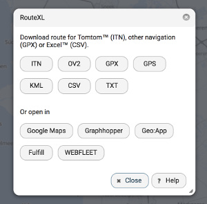
If you have a route planned and push the Download button, several file format are available for download to your device.
Formats
- ITN - TomTom itinerary file, which can be loaded on some older models TomTom GPS devices. Recent models use GPX (read more).
- GPX - GPS Exchange Format (XML), which can be loaded on several GPS models, like Garmin. This file only holds the destinations, no route. Use this if your device is able to navigate from between stops.
- GPS - Same as GPX but with all route waypoints. Use this if your GPS has no road network and you need the full path from our route planner.
- KML - Keyhole Markup Langange file, that can be used with various geographic applications, like Google Earth.
- CSV - Comma separated file that can be used for several office applications. Recommended for use with Excel.
- TXT - Flat file that only holds your destinations as text.
Export
You can also export routes to other online route planners, Google Maps and Graphhopper. Those websites may have additional options to use the itinerary, including routing for other vehicles, like bike or foot (walking). Hit one of the buttons to export your route to these websites. A new window or tab will be opened.
IMPORTANT: these route planners are reported to set limits to the number of stops in a route, change their policy or their interface. E.g. Google Maps has been reported often to accept only a maximum of 20 stops per route. The export may fail due to these measures. Unfortunately RouteXL has no control over this, but offers some alternative methods.
On a smartphone or tablet you may start a navigation app with the route with all stops. Note that not all navigation apps will accept large routes or routes with multiple stops.
Fulfill
To navigate to each stops one by one, start the fulfillment dialog.
WEBFLEET
If you have a TomTom Telematics WEBFLEET account, you can also export the route to that platform.
Demo's
Some demo videos with various downloads are available on our Youtube channel.
